The 8/26/2012 ZetaTalk Newsletter is circulating that Luzon, the main island in the Phillipines, and specifically the city of Manila, are flooding because of a 40-foot drop in coastal elevation. I searched the internet and didn't find anything on an elevation drop, so I asked someone I know who lives there. It was news to that person, who said that Manila is several feet below sea level and they are having heavy rains. See also, http://ketsanaondoywatch.wordpress.com/2009/10/09/elevation-is-no-guarantee-for-protection-in-metro-manila/. Here is an article about Luzon and how the heavy rains are causing dam personnel to release water so the dam doesn't overflow: http://newsinfo.inquirer.net/249103/central-northern-luzon-brace-ahead-of-new-storm.
For background information, this link was referenced in the ZT Newsletter, showing where the 40' elevation loss figure comes from. By the way, the newsletter was available by email for many, many years. Lieder recently notified the world it would no longer available by email, only from the zetatalk website (the motivation being, I think, to make it easier to rewrite history when her wild predictions, leaping before verifying, and other "news" are debunked).
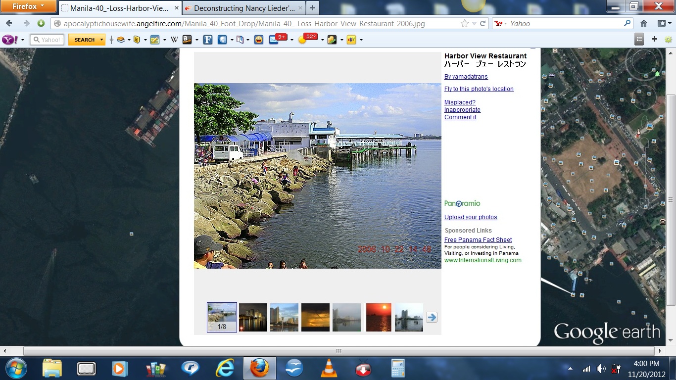
Since the current ZetaTalk states that the 40' loss of elevation had already occurred prior to the October 2011 MODIS image that was "glanced at," I went direct to MODIS to review earlier images, and spent considerable time following the coastline looking for signs of elevation loss. I didn't find any, but what I did find was the Harbor View Restaurant that is situated on a jetty that protrudes out from the mainland of Manila. This first image is from 2006 and shows how it relates to Manila Bay, how tall the pier is, etc.
As you can see on the above image from GoogleEarth, the Harbor View Restaurant is on a jetty out from mainland Manila (white arrow bottom right). So, if a 40' drop in elevation occurred along the Manila coastline, one would assume that the restaurant ceased to exist, but that is not the case. They are still in business as these next pictures from 2010, 2011, and 2012 show ...
That's pretty much conclusive evidence, but just to nail it down more, I noticed that there were signs of heavy rain run-off, as well as docks in Manila which were not submerged either...
Manila had been experiencing heavy rains then (2011) because it was the middle of monsoon season plus a typhoon had passed through mere days before. Here are some news links and facts about the weather:
Schools were closed for the early August 2011 typhoon: http://www.goodfilipino.com/2011/08/august-2-2011-suspension-of-classes-in.html.
Manila was swamped by it: http://english.sina.com/world/p/2011/0802/385097.html.
And before the August typhoon, it had experienced more rain. See http://en.wikipedia.org/wiki/2011_in_the_Philippines#August, so there was an overload of rain.
May 8/9 - Typhoon *"Bebeng" entered the Philippine area of Responsibility, and hits Bicol region where 20 people reported dead while 2 still missing.
June 20/27 - Tropical storm Falcon dumps heavy rain in Luzon led to a series of floods leaving 2 people dead and 5 missing.
July 26/27 - Tropical Storm Juaning hits the Philippines where 31 died while 27 still missing.
July 31 - Tropical depression Lando sighted in the West Philippine Sea, and it joined with Kabayan, which they are the cause of rain in some parts of Metro Manila.
August 2 - Typhoon Muifa swamps Manila
August 8 - youtube of rain pouring... *** https://www.youtube.com/watch?v=G3mWfp5MbPk
And, remember, August 2011 was five months after the Japan earthquake. Don't know if the Phillipines received flooding from that.
***"After being hit by 48 hours of consecutive rain and flash flooding across the majority of Metro Manila, on the third evening the rain began to increase, not only in the intensity of the rain storms, but also the length of the rain storms. This video was taken 5 minutes into the storm and 15 minutes later the intensity is the same."
Currently, August 2012, shows similar conditions existing. http://www.tampabay.com/incoming/relentless-rains-trigger-deadly-landslide-submerge-half-of-philippines/1244729. An internet search produced no articles regarding a 40' loss of coastal elevation around the Phillipines. Just the loss of Manila's docks alone would have been international news.
And, Manila has a poor drainage system, to boot:
Metro Manila clogged drainage causes flood and traffic June 25, 2011: "The Metropolitan Manila Development Authority admitted, on Thursday, that clogged drainage systems and unfinished road repairs are also to be blamed for the flood and heavy traffics that Metro Manila recently had to experience."
Flooding in Manila, Philippines September 19, 2011: "The Metropolitan Manila Development Authority reports numerous reasons for the flooding. Flooding in June of 2011 was partially due to the overflowing of Talayan Creek. Poor drainage in sewers is another common reason for flooding, especially in downtown Manila. Water lilies were partially responsible for recent flooding in Mindanao in Southern Philippines; lilies blocked a 200 mile stretch of the Rio Grande, the longest river in the Philippines, preventing water from emptying into the Moro Gulf."
UN Cyberschoolbus: Manila, Philippines "Metro Manila has serious infrastructure and environmental problems in the areas of land, water, air, sewerage, drainage, waste, and traffic. ... The huge amounts of solid waste produced by the city each day often clogs the poor drainage pipeline and causes eventual flooding".
Epic Flood In Metro Manila Caused By Record Rainfall" "... other factors such as Metro Manila�s poor drainage system, pollution, and garbage problem might have worsened the effects of the heavy downpour that �Ondoy� brought to the area."
Huge floods in Manila as typhoon hits Philippines September 27, 2011: "Manila residents waded through waist-deep floodwaters and dodged flying debris Tuesday as a powerful typhoon struck the Philippines, killing at least 12 people and sending waves as tall as palm trees crashing over seawalls. ... Most deaths occurred in metropolitan Manila, which already was soaked by heavy monsoon rains ahead of Typhoon Nesat's arrival with more downpours and wind gusts of up to 93 mph (150 kph). Downtown areas along Manila Bay suffered their worst flooding in decades. ... Emergency workers evacuated river areas in Manila that are notorious for flooding. ... Seasonal monsoon rains ahead of the typhoon plus winds pushing seawater inland had worsened the situation, forecaster Duran told the AP. "Land is saturated with rain so the next rain became run-off and was already floodwater," he said. The wind sent storm surges over an embankment that then trapped water on the city side so that it "couldn't flow back to the bay," said Francis Tolentino, chairman of Metro Manila Development Authority."
Philippine floods a man-made disaster�experts August 9, 2012: "Deadly floods that have swamped nearly all of the Philippine capital are less a natural disaster and more the result of poor planning, lax enforcement and political self-interest, experts say. ... Damaged watersheds, massive squatter colonies living in danger zones and the neglect of drainage systems are some of the factors that have made the chaotic city of 15 million people much more vulnerable to enormous floods."
So, that which is being claimed to be a loss of elevation appears to be submerged coastlines caused by back-to-back storms, inadequate drainage, run-off from heavy rains, including dams and rivers overflowing. When Lieder squawked about Indonesia sinking, I did a similar study in 2011 regarding Kronja, near Jakarta, Indonesia. See here. And how does the runoff get to the coasts? By the 37 rivers in Luzon, three of which are in and around Manila. See http://en.wikipedia.org/wiki/List_of_rivers_in_the_Philippines.
I didn't follow all the coastlines, but since Manila was considered as having the same 40' foot elevation loss--no distinction was made, the entire western side of Luzon had the exact same 40' elevation loss (which is odd all by itself), I think the docks not being submerged in Manila speak to the rest of the coastlines.
The following discussion about docks is not important since I found other ways of showing no loss in elevation. I'm leaving the italicized portion to preserve the research. There's more below it.
I looked around for how high a commercial dock is from the waterline and that information is one of the few things on which Google fell short. I did, finally, find this: http://en.wikipedia.org/wiki/Samsung_Heavy_Industries. "The largest of the three docks, Dock No. 3, is 640 meters long, 97.5 meters wide, and 13 meters deep (42ft8in). Mostly ultra-large ships are built at this dock...." Remember, this is a supertanker size dock, which would be the largest dock. Most docks would not be that large (meaning the pier platform would not be as deep).
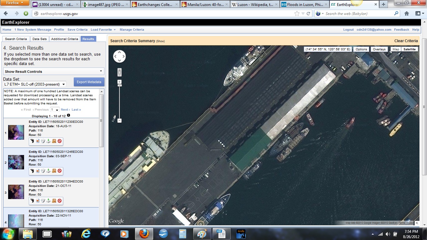
I'm not sure how far above the waterline the dock/pier is, but from the pictures it didn't seem like much (link below). It seems that a 40' drop in elevation would submerge most docks. Thus, the August 2011 image shows five docks that are not submerged, which lends weight to the conclusion that a 40' elevation loss has not occurred. In fact, less than a 20' loss would likely submerge most docks.
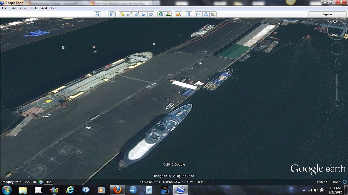
Then I got to thinking whether the 42'8" was the thickness of just the platform, which might be up on pilings like smaller docks are. So I went to Google Earth and zoomed in on one ship at a dock in Manila and the elevation was around 19 feet above sea level, depending on where the cursor was. The range was 13 to 22 feet when I rolled the cursor all around the ship, higher on the dock side, less on the far side of the ship. (Note in the bottom left corner of the following images that the image date is 2/4/2010. No obvious loss of elevation then, either, though the point of these pictures is to show the elevation, not loss of elevation.)
Here's the above image zoomed out a bit. It says the elevation is 20'...
The image in this next link shows a wharf that is not much above the water line (not sure if it is South Harbor because the same picture is shown for North Harbor as well... http://mcgutib.wordpress.com/2009/06/27/featured-ports-pmo-south-harbor/. The article indicates that the water depth at the piers in South Harbor is between 26' to 30' for the oil terminal and 36' to 40' for the cargo pier.
This next link shows the Port of Calapan City in the Phillipines, south of Manila, a much smaller port with smaller piers: http://mcgutib.wordpress.com/2009/06/17/port-of-calapan-city/"
Conclusion. If the coastline had sunk 40' then all of the South Harbor (Manila) piers, at an elevation of around 20' above sea level, should be under 20'+ of water. Further, it seems logical that a loss of elevation would have displaced the pilings, making for an uneven loss, even collapsing some or all the piers. The Super Terminal at Pier 15 took approximately nine months to build, so it couldn't have been submerged then rebuilt quickly. The Calapan City port would have ceased to exist.
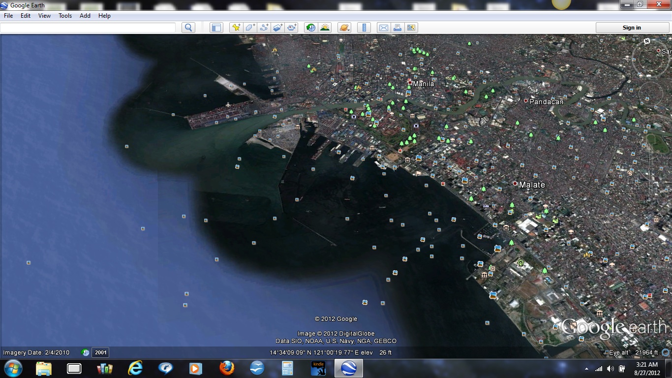
And to really beat this dead horse, here is an image of a large river that flows behind the port for miles over to the Laguna de Bay. Notice the color of the river and the color of the water as it enters the bay. It's obviously runoff submerging low-lying land...
And here's the other end, where the river empties into the Manila Bay, the greenish water to the left of the piers. I'm assuming the black water is build-up of silt from prior rains/runoffs. The pattern of the greenish water seems to indicate that. FYI, these are large piers, according to http://www.virtual-asia.com/ph/philippine-port-profiles.htm": "South Harbor has five piers numbered from north to south as Pier 3 (four berths), Pier 5 (five berths), Pier 9 (five berths), Pier 13 (seven berths) and Pier 15 (four berths). These are large piers, 83m to 103m wide and 350m to 400m long."
So, has the west coast of the Phillipines, especially Manila, had an elevation loss of 40 feet? I think not.