
INDONESIA & PAKISTAN SINKING? TECTONIC PLATES SAID TO BE COLLAPSING UNDER PAKISTAN AND INDONESIA ARE NOT COLLAPSING!
Since this blog was posted, we've done some investigating. Read the original blog first. Below it are updates that show the findings of the investigations....
ORIGINAL BLOG:
The time prediction failed and this isn't something that shocked the world. This news isn't widespread in the media, even if it was the world would not be shocked. Concerned, troubled, but not shocked. I still think the prediction is man-based, not Zeta based. This next link is just regurgitation of ZetaTalk.... Tectonic Plates Collapsing....
"Tectonic changes are now coming in fast succession.
"Pakistan has officially lost land elevation.
"Bangkok, Thailand is also experiencing difficulty in getting flood waters to drain off.
"Jakarta, Indonesia on the Island of Java is sinking as roads and land along the drainage canals is collapsing.
"Viet Nam is witness to an epidemic of sinkholes, another indication of land and tectonic plate subduction.
"The Philippines Tectonic Plate is now sinking with flooding reported.
"What is now being reported the Indo-Australia tectonic plate began to tilt on the western region on that tectonic plate where Pakistan is today located. As the land subsided, the flood waters were now trapped. The news that has not been reported is that much of this flooded region will never be recovered, for it is now permanently under water in Pakistan’s new lake district; no homes, no farms, no crops, and now starvation.
"The tilting of the Indo-Australian Plate caused an adjustment in the sub-oceanic regions as far as the KTT (Kermadee Tonga Trench) when in September 3, 2010, the sub-oceanic trench that runs straight across New Zealand’s 3rd largest city, Christchurch, a large 7.4 magnitude earthquake devastated large portions of their beautiful city. This tectonic adjustment put pressure on the “tongue” of the Eurasian Plate pushing down into Indonesia and that island nation began to sink. This again has not been reported in the international news.
"Six months later, December, 2010, the Earth Observatory, operated by NASA admitted that with comparing satellite images of Pakistan from 2010 and one year earlier, the elevation of Pakistan had dropped – 10 feet."
Okay, that's what's being claimed. HOWEVER....
UPDATE 02/05/2011:
KeithH did some investigation and posted his findings in the comments below. I am copying them here for ease in finding them:
From KeithH...
I have discovered some very interesting information concerning the images that have been used supporting the sinking of Indonesia.
1. The images that are used are verified by TruEarth to be from the circa year 2000. The disclaimer page at TruEarth also states this fact in addition to further clarification from their website.
See the text highlighted in blue at the bottom of this next image...
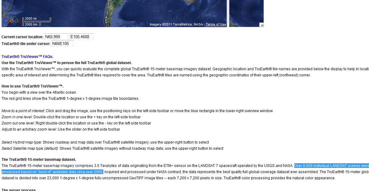
So the images used from approximately the Year 2000 confirms the sinking of Indonesia? I think not. Comparing images from the year 2000 to claim a 20 foot drop in elevation for the entire North Coast of Java now, the only thing I can deduce is current flooding during the Monsoon Season. Tragic of course, but not unusual.
Anyone could forecast heavy rains and flooding during the Monsoon Season and be correct.
2. Due to the low lying elevation and overcrowding of Jakarta, talk of moving the capital has been discussed for many years. The drainage system was built by the Dutch at least a century ago. Indonesia Mulls Plans To Relocate Capitol City. "Indonesia has been thinking about it on and off for more than a half-century."
The Sea Level Monitoring site has no stations on the North side of Java. No evidence to support the claims that the entire North Coast of Java is sinking.
During the Monsoon Season, one can expect some flooding. Even when a levee breaks, the levee was probably built to keep the sea in check. Logically, sea level would rise and fall at predicted high and low if the levee had been breeched. {http://translate.google.com/translate?js=n&prev=_t&hl=en&am......}
Here is a link to Jakarta traffic web cams. Not much evidence of flooding there.
If the situation in Jakarta was so dire, why hasn’t Janet Jackson canceled her scheduled concert performance on February 9, 2011?
Media blackout? How can anyone black out any information that is not substantiated? If nothing is going on, there is nothing to report.
That leads me to the question of why NL is grasping at every small tidbit of information to support her theories. We can only guess. The truth always stands up to scrutiny.
She keeps saying to look at the satellite pictures and the images are over 11 years old!!!
I am sure I will be labeled as a government disinformation artist and shrill, baboon that slings feces, and on the verge of a nervous breakdown. This is only because I question her statements. She has no other response.
She has quoted NASA on the Indonesia post, NASA, whom she has claimed in the past, and raised suspicions, which she claims is not telling the truth. Doesn’t one find this odd? Now she wants to use NASA as source of her statements.
She also stated that it is expected that she may not be able to use these images much longer on the Zetatalk Newsletter, a scheme to incite someone to claim these claims were not true and give her a further way out? Appears to be disinformation on her part.
Her latest Newsletter ignored Issue 225, only to avert focus on South America. Next week it may be North America. Possibly predict a major earthquake in Japan?? That has already been happening.
I challenge her to prove that Indonesia and the Philippines are sinking, without quoting Zetatalk. I have seen no evidence to the contrary.
Home